


The Environmental Protection Agency says Cold War-era radioactive waste dumped at the West Lake Landfill decades ago remains contained within fenced areas and isn’t seen as a public health threat.
That is the conclusion of a radiological survey of the West Lake Landfill Superfund site conducted by a specially equipped aircraft on March 8. The survey was requested to help provide fresh data that will be used to guide decisions about management of the site.
“The aerial survey has shown that the radiological contaminated waste that was buried at the site during the 1970s remains contained within secure fenced areas,” EPA Region 7 Administrator Karl Brooks said during a conference call. “Secondly, those radiological wastes do not pose health risks to the public.”
Brooks said the new information should provide comfort to concerned neighbors. But the EPA had no answers to the questions and criticisms of those pushing to have the radioactive waste excavated and disposed of in a licensed facility.
People are also reading…
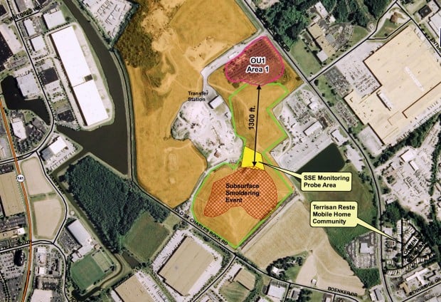
Chief among those concerns right now is a fire deep in the belly of the adjacent Bridgeton Sanitary Landfill.
The main concern is that the subsurface fire could eventually reach the radioactive waste.
Earlier this month, Missouri Attorney General Chris Koster estimated smoldering garbage was within 1,000 feet south of one of two areas known to contain radioactive material.
The owner of the Bridgeton Landfill, Republic Services Inc., estimates the distance at 1,200 feet. It said the fire’s movement has slowed and containment efforts are working.
The EPA tried to provide assistance. It conducted infrared imaging of the Bridgeton Landfill during its aerial survey to help the Missouri regulators assess the fire’s extent. But two passes over the site didn’t provide conclusive data, partly because of the depth of the fire from 40 to 160 feet below ground, the agency’s report said.
Brooks skirted follow-up questions about the location of the fire and the proximity to radioactive waste, saying only that the Missouri Department of Natural Resources was the agency responsible for oversight of the Bridgeton Landfill. The EPA is in close contact with DNR and independently reviewing the same data, he said.
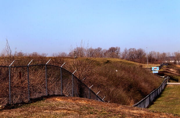
Radioactive waste is contained in two areas (Area 1 and Area 2) at West Lake that cover about 40 acres of the 200-acre landfill north of Interstate 70 and west of St. Charles Rock Road. The Missouri River is less than two miles to the northwest.
The EPA said its aerial survey showed levels of gamma radiation that were “significantly higher” than background radiation levels in Area 2, which is the northernmost of the two areas.
Plans to manage the site call for leaving the contaminated soil in place and trying to contain the environmental risk by covering the site with an earthen cap and installing a groundwater monitoring system.
The decision prompted a backlash from environmentalists, politicians and local governments when it was announced in 2008. Bridgeton, Florissant, ӣ����Ƶ and ӣ����Ƶ County all passed resolutions urging the agency to reconsider the plan, citing the landfill’s location in the Missouri River floodplain.
Activists and a growing number of North County residents who share information on Facebook continue to pressure the Army Corps of Engineers to take over the cleanup of West Lake site. The Corps of Engineers is the agency carrying out cleanups of other area sites with radioactive contamination.
The EPA, in response to criticism, ordered parties responsible for the site — Cotter Corp., Republic Services, Rock Road Industries LLC and the U.S. Department of Energy — to commission a supplemental study of cleanup options.
That study was completed in 2011. It doesn’t make specific recommendations, but estimates that the cost of removing the waste and hauling it to a disposal facility could be more than $400 million. By contrast, covering the waste is estimated to cost $41 million.The EPA will hold a public meeting at Pattonville High School on June 25 to discuss results of the radiological survey and plans for additional groundwater testing.
EPA’s aerial survey follows last week’s release of DNR tests of gamma radiation measurements taken May 16. Those tests showed radiation levels upwind and downwind of the landfill were consistent with naturally occurring radiation levels.


